Managing Malaria Spraying

Malaria remains one of the major public health problems on the African continent. Each year, between 300 and 500 million new cases occur, and about 900,000 people die from the disease. Ninety percent of deaths in Africa are children under 5 years of age.
The U.S. President’s Malaria Initiative (PMI), introduced in 2005, aims to reduce malaria-related mortality by 50% in 15 African countries. The U.S. Agency for International Development (USAID)—in conjunction with the U.S. Centers for Disease Control and Prevention (CDC), the U.S. Department of State, and the White House—leads this initiative. PMI uses the following four key malaria vector control interventions:
- Rapid diagnostic tests followed by treatment with artemisinin-based combination therapy
- Intermittent preventative treatment in pregnancy
- Long-lasting insecticide-treated nets
- Indoor residual spraying (IRS)
RTI International has been working for over 12 years to prevent and control vector-borne diseases such as malaria.
IRS is an application of a residual insecticide to the interior walls of human dwellings. After biting, mosquitoes rest on walls to digest the blood meal, where they absorb a lethal dose of insecticide. IRS aims to kill female mosquitoes before the infective stage of the malaria parasite can develop. Data shows that if at least 85% of households in a community are treated, IRS can prevent transmission. Managing the logistics of household mapping, spray teams, and supplies, requires the ability to collect and analyze quality data from on-going spray operations.
Solution
 The Zcore-IRS (Indoor Residual Spraying) application helps USAID-supported IRS operations in Kenya to collect and aggregate data from on-going spray operations at remote field sites. Data for each day's spraying, including details about each house sprayed or the day's spraying totals, is entered into the application. At the end of each data entry session, data are uploaded to the main data center and are available for reports.
In 2008 a demonstration data system named IRSA was created by RTI using Eclipse RCP and an early version of the Zcore framework. In June 2010, a new version of the application, called Zcore-IRS, was developed with an updated version of Zcore used on other data collection projects in Kenya and South Africa. This new version was deployed at three sites between Kisumu, Kenya and the Tanzanian border, and was used to enter data from paper records and import data collected on GPS units.
How is Zcore-IRS being Used?
The Zcore-IRS home page enables the user to search for spraying information by date.

Data Entry
The user begins a data entry session by clicking the "SOP Summary" link at the top of the home page. She or he may then create a new Daily Spray Card "header," which records date and location information about that day's spray sessions.

After the header is created, the user is able to enter information about the spraying conducted at each household. Data about the number of children, pregnant women, rooms sprayed, and insecticide-treated bed nets used are transferred from paper to the Zcore-IRS software application.

GPS Data Collection
A "mapper" travels with each spray team and uses a handheld Global Positioning System (GPS) receiver to record the GPS coordinates at each household visited. In addition to the GPS coordinates, the mapper also enters codes next to the time stamp to record the number of structures, number of persons in the household, number of children, number of pregnant women, and number of bed nets ("Details" column in the screenshot below). At the end of the day, the GPS data are exported as an XML-formatted file (Garmin .gpx format) and imported into the IRS application. This operation is automated so that it is easy for users with minimal training. These data may be used for checking the accuracy of the Daily Spray cards.

Data Output

Data may be output from the Zcore-IRS application either as an Excel Comma Separated Value (CSV) file, or may be synchronized to a Master instance of the Zcore-IRS application automatically by using Zcore synchronization. Each data entry location was equipped with USB wireless broadband adapters that enabled data transfer to the main RTI office in Nairobi via the 3G mobile phone network.
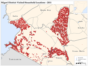 GIS Mapping
Data from the Zcore-IRS database were then used to create a series of maps using a Geographic Information System (GIS). Maps of each district include household locations, the population of each household, number of children under five years of age in each household, number of pregnant women in each household, and households owning insecticide-treated bed nets. The maps were used to plan and monitor IRS spraying operations.
Use of GIS system enables advance spatial analysis and can help to improve resource allocation and the logistics of gettng spray teams and supplies to target areas.
More Information
- View a training screencast for early version of IRS - 6:30 Flash presentation - This screencast demonstrates data entry and GPS data import into the IRS application. You must have Flash enabled in order to view the screencast.
- Download Zcore-IRS software
- Learn more about Zcore open source software
- Printer-friendly version
- Login to post comments
 PDF version