Reporting Crimes
 El Salvador suffers from high levels of crime and violence that undermine citizen security, retard economic development, and erode good governance. Gangs have been a salient feature, but the sources of insecurity are not limited to gang activity. Violent crimes, as well as petty crimes, are prevalent throughout El Salvador. El Salvador has one of the highest homicide rates in the world.
National and local governments in El Salvador share responsibility for preventing and responding to crime and violence. Their objectives include reducing the spread of crime, identifying contributing factors, and developing effective crime and violence prevention strategies. Multi-jurisdictional coordination requires standardized processes for collecting, analyzing, and sharing data.
At the beginning of this project, only four municipalities in El Salvador were able to map the incidence of crime: Santa Tecla, Santa Ana, Ahuachapa, and San Martin. Only Santa Tecla was using a Geographical Information System (GIS) connected to a crime mapping database. The other three municipalities were mapping crimes by placing markers on Google Earth manually. The Santa Tecla Municipal Crime Observatory Inter-Institutional Council needed to map the incidence of crime accurately in order to allocate limited resources more effectively and to target community-based interventions to reduce crime.
Unfortunately the manual data collection and processing system was slow and the labor intensive. Data completeness and quality were also important concerns. For example, data entry and geo-coding errors could remain undetected. While the existing system was more advanced than that of other municipalities in the country, it still did not provide the accurate on-demand maps needed to adjust law enforcement tactics and resources or to plan and monitor community development interventions that may reduce crime.The city needed a solution to gather crime-related data quickly, share it between agencies, and deliver it to the city's Crime Observatory for analysis and reporting to the Mayor. This was previously done using spreadsheets, which slowed data collection and lacked important features, such as accurate information concerning the locations of crimes.
Solution
RTI, with funding from Qualcomm Inc., developed a system integrating mobile data collection with web-based mapping, and advanced GIS-based analysis.
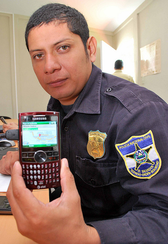
Seguridad Inalámbrica (Wireless Security) allows both the national police (PNC) and municipal police (CAM) to gather information from the field using smart phones, to seamlessly add geographical information to each event, and to transmit event data back to a central location where the data could be reviewed and edited if necessary. Once event data are transmitted to the system each member agency can access the information for analysis.
Law enforcement agents participating in the project have been issued 3G mobile phones running an easy to use, crime reporting software application. The devices and software application are used to report each crime from as close as possible to the location where the crime occurred. Information about the nature and location of the crime are transmitted from the smart phone handset to a crime mapping database. Crime reports can then be mapped from the crime database using open source Geographic Information Systems (GIS) software. The system displays incident data on detailed maps of the city. This facilitates the identification of high-risk locations and helps track changes in crime patterns over time as law enforcement agencies’ crime and violence prevention programs are introduced.
How it Works
After analyzing alternatives, RTI selected Ushahidi as the web-based component of the project. This open source software system was already developed, and there were several developers around the world eager to help improve it. This facilitated a quick start and ensured strong technical support. Based on PHP and MySQL, a common product combination for open source software applications, the system is simple for most software developers to understand and to modify.
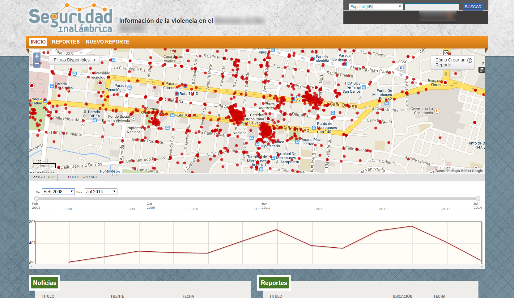 The main screen of the web-based system shows a detail of the city and the location of the events. Only events that have been approved by an operator are shown on the map. By request of the agencies involved, the site requires authorized users to log in to the website before they can access to this information.
Reported events are classified based on categories that closely match the legal categorization for criminal and regulatory offenses. A timeline plots the incidence of events in each category over time.
While the site leaves advanced geographical analysis to a GIS system, some limited analysis that can be done based on the categories, time, and overlay information, which allows different layers to be superimposed on the map. In the screen on the left, the "Zonas" layer will show the different patrol areas set by the PNC.
The system has a complete API (Application Programming Interface) that is easy to adapt the software to the needs of other applications.
Mobile Application
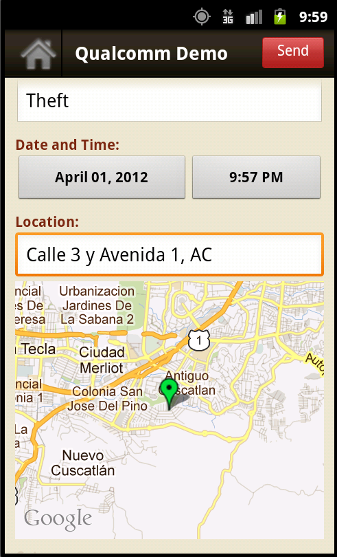 RTI developed a simple, multilingual, and fully-configurable data-entry application for the mobile phone to allow law enforcement officers to submit crime incident data, including geographical information, remotely. The application was designed around key data elements, and was developed iteratively during training and implementation. This allowed RTI to better observe and understand user needs, and for users to be involved in developing the system.
The application allows a law enforcement officer to enter a new event in less than one minute. Data collected to date indicate that the time it takes law enforcement officers to enter data decreases as they become more proficient with the mobile phone handset application.
Geographical information can be entered on the mobile phone handsets by manually selecting a location in a map, by using the GPS receiver built into the mobile phone handset, or by using nearby cellular towers to estimate the location of the handset. These options provide flexibility, and enable users to enter the location of an event even if they are no longer at that location. For example, if a user has left the location where the event occurred, the user can enter the location manually, use the built-in GPS transceiver and map to obtain precise location, or let the software estimate the location based on the locations of the nearest cell phone towers. This last method works even if the user is inside a building.
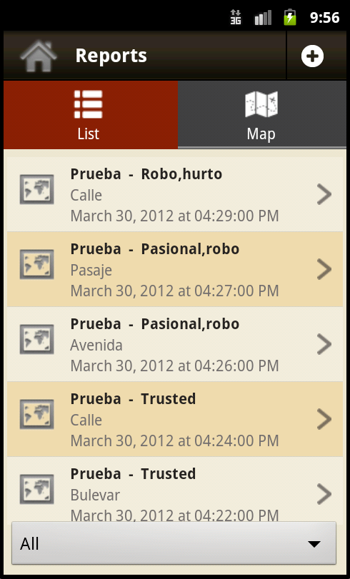
Once one or more events have been entered into the mobile phone handset application, the user can synchronize it with the central data repository. The software application does this by using the web-based system's API to enter new records in the central database, and to query the system for the latest records entered by other users.
Law enforcement officers found it valuable to be able to receive updated information from other users on their mobile phone handsets. Officers are using this feature to stay updated on the latest events and to reinforce daily crime briefings. The need for this capability emerged as RTI worked closely with users during system development.
Data transmissions from mobile phone handsets and all communication with the website are protected by Secure Socket Layer (SSL). Each mobile phone handset can also be assigned a unique API key that is then verified by the server. This keeps "rogue" units from accessing the system remotely, and can allow the agencies to keep a lost or stolen unit from submitting data.
Backend
Local ownership and capacity are essential to the sustainability of the system. Local system owners must, over time, become the managers, maintainers, and developers of the system. The participating agencies posses the necessary technical skills, but constrained budgets and limited ability to add new staff limit support capacity. Therefore the simplicity of the system was a key design requirement.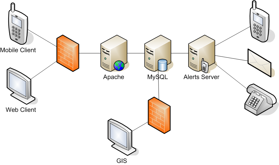
The core of the system is a PHP application running on Apache web server, using MySQL as the database storage engine. This runs on a Linux (CentOS) virtual machine based on the Xen hypervisor. This is hosted with a global hosting provider, which eliminates the need for a dedicated hosting environment. RTI runs its own Xen host, and can quickly and easily replicate an instance of the system.
Access to the system is protected by a firewall. Usage statistics for the website are collected and analyzed using Webalizer.
The system can incorporate a component that can alert designated phone numbers SMS text messaging or computer generated voice calls, and can send email to designated email addresses.
Advanced spatial analysis is provided by a GIS application, which can directly access the data stored in the main database, after authentication and subject to the policies set by the system. GIS applications current have read-only access to the database.
The system is monitored automatically by a Nagios instance running on RTI servers, making the solution an end-to-end open source implementation.
GIS analysis
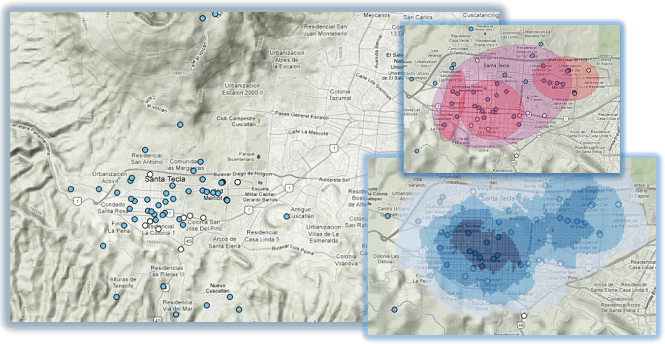
To assist the Crime Observatory, RTI reviewed alternative GIS tools, created the necessary views to the data in the database, and provided training to Crime Observatory staff members. To avoid the licensing costs of some GIS packages, RTI chose Quantum GIS as the GIS platform for the project, and CrimeStat as the data analysis tool.
Quantum GIS provides most of the features of first-line GIS programs, while being simpler to use than other open source applications (i.e. GRASS). The addition of CrimeStat (another free software product) allows the Observatory to perform crime-related analysis on the information collected, including:
- Spatial distribution and correlation
- Distance analysis, "hot spot", and density analysis
- Interpolations
- Journey-to-crime analysis
- Bayesian analysis
Using these tools, the participating agencies can have a deeper view into the crime-related data, can observe changes over time, and can analyze and plan prevention policies. The analysis can be programmed to be performed automatically at regular intervals, with results send to key stakeholders, or even posted online.
Training
After assessing existing computer literacy and skills, RTI concluded that ease-of-use would be key to successful implementation of the system. The mobile and web-based systems provide a simple user interface and allow users with no previous experience to be trained quickly.
Users were trained initially by RTI staff in a classroom setting that replicated a normal deployment. Classroom equipment included 10-15 computers and a similar number of phones. After an explanation of the goals of the project, the components of the system, and the processes of entering, processing, and visualizing data, training participants were divided into two-person teams. One person operated the web-based application while the other use the mobile data collection tool. Roles were reversed later to allow for an even experience.
This hands-on training not only provided an excellent exposure to the technology (for some agents it was their first time using a web-based system), but it also allowed RTI trainers to determine which users had the best personal and technical skills. These users became "assistant trainers" as the training schedule moved forward, which helped develop a peer-based training model, and created internal experts and trainers.
Between RTI-led courses, and courses provided by the in-agency coaches, approximately 150 agents were trained to use the system.
Implementation timeline

The project started in August, 2009. The first version of the application was completed in December 2009 for the Windows Mobile operating system. After a several months of testing and training, the pilot project was officially launched in Santa Tecla in May 2010. The pilot project ran until December, 2010, at which time it was evaluated.
In 2011 and 2012, RTI redesigned the application for the Android operating system and deployed the new version in the municipalties of Antiguo Cuscatlàn and San Martìn, as well as updating the application in Santa Tecla. District 1 of San Salvador also began entering reports into the web-based system.
RTI is currently working with partners to build on the results of 2012, expand use of the system, and strengthen sustainability.
Partners
Qualcomm Incorporated, through its Wireless Reach initiative, has provided funding to RTI International (RTI) to roll out this system. Funding supports project strategy, system design and development, training, implementation and management oversight. Seguridad Inalámbrica aspires to create a sustainable crime mapping foundation that can be tested and proven in Santa Tecla and eventually implemented in other municipalities and other countries in the region.
Project partners include the following:
- Planning Office of the San Salvador Metropolitan Area (OPAMSS)
- The National Civil Police (PNC)
- Municipal Observatory for Prevention of Violence in the municipalities of Antiguo Cuscatlan, San Martin, San Salvador, and Santa Tecla. In October 2013 the municipalities of Apopa, Ayutuxtepeque, and Ciudad Delgado also signed memoranda of understanding to join the project.
- RTI International
- Millicom / Tigo El Salvador
- The U.S. Agency for International Development (USAID) Crime and Violence Prevention Project
- The United Nations Development Programme (UNDP)
- Qualcomm's Wireless Reach initiative
Articles and Publications
- Project information at Qualcomm Wireless Reach
- Project video
- Wireless Security System Project Expands to San Salvador's Metropolitan Area
- Advanced Wireless Broadband Technology Will Help Reduce Crime in El Salvador
- Wireless Reach Case Study: El Salvador, Wireless Security (English)
- Seguridad Inalámbrica 2 on Facebook (Español)
- Login to post comments
- Printer-friendly version
 PDF version